


ROAM GPS: Offline Maps for Hiking, Biking, & More!
INTRODUCING THE ROAM APP BY ONXMAPS
ROAM turns your phone or tablet into a handheld GPS w/ extensive outdoor map data! Find new places to recreate using the most complete public lands & open spaces maps ever created. Going out of cellular data coverage? No problem! Your GPS works even without cell service and you can save your maps and markups for offline use.
•Turn Your smartphone or tablet into a powerful handheld GPS
•Discover new trails by browsing the most comprehensive nationwide trails map ever created
•Find Open Space w/ onXmaps’ accurate Public Lands data
•We’ve combined all your paper maps into a much more customizable digital map suite.
•Turn Map Layers and Basemaps on and off to customize your maps for your favorite activity
•See Recreation Access Areas and Water Sports Access Points
•Switch between comprehensive Base maps including Aerial imagery, 24K topo, and Hybrids
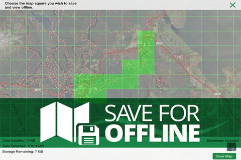
•Save Maps for Offline Use when out of cell coverage
•Create Geotagged Photo Waypoints and Customized Waypoints
•Auto-Sync and Share Waypoints, Tracks, Measurements, and Stats w/ your Team and between your devices
FREE TRIAL
While the App and many of it’s features are free. You will start a free Roam Nationwide & State Private Parcels trial when you install the App. This allows you to try our full app for 7 days. Roam Nationwide membership is $9.99/year & state private parcel memberships are $19.99/year.
ROAM APP FEATURES
▶MAP DATA FEATURES
• Public Lands: Nationwide Federal & State (the most accurate & complete nationwide dataset ever created)
•City & County Open Space
•Trail & Trailhead locations, names & numbers
•Geographic & Recreational Point of Interests
•Water Data
•Weather & Radar
•Campgrounds & secluded Campsites
•Ski runs & lifts
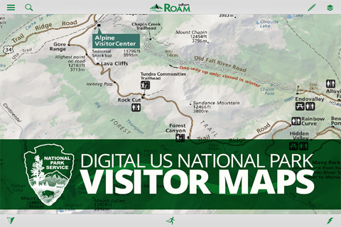
•National Park Service Visitor maps
•National Forest Visitor Maps (save thousands on paper maps!)
•Motor Vehicle Roads & Trails (MVUM) displaying National Forest System (NFS) Routes (roads & trails) open to motorized travel
•Nationwide USFS Roads
•Nationwide USFS Trails & Wilderness
•USGS Gage Stations
•USGS Snotel (snowfall measurements)
•Wildfire Historic Perimeters
•Active Fires
•Private Landowner Names w/ Property Boundaries
▶BASEMAPS
•USGS Topo (Quads)
•Aerial Imagery
•Imagery+Topo Hybrid
•OpenStreetMap
•USA Topo Maps
•Ocean BaseMap
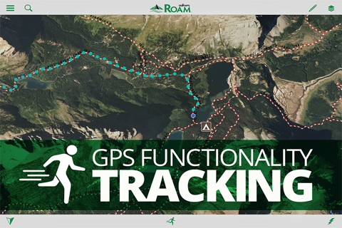
▶GPS Functionality on Your Phone or Tablet
•GPS Location
•Mark Waypoints
•Tracks
•Compass Mode
•View elevation profiles
▶TRACKING FUNCTIONALITY
•Active track on/off
▶MARKUPS & DRAW TOOLS
•Place Points on the map
•Geotag Photos
•Use Custom ROAM Waypoint Symbols
•Draw Lines
•Draw Shapes
▶ MULTIPLE DEVICES (my.onxmaps Cloud sync):
• ROAM anywhere! One account gives you access across multiple devices.
•Simply log in to your account & access all your map content that is automatically saved to your account
▶SHARE VIA SOCIAL, TEXT, OR EMAIL
•Tracks
•Markups
▶MEASURE TOOLS
•Distances
•Perimeters
•Areas
▶SEARCH
•Search for nearby places
•Points of Interest
•Landowner Names
▶AUTOMATIC MAP UPDATES
•The newest map data is automatically streamed into your device w/ no cumbersome update process
▶‘USE SAVED MAPS MODE
•Forces the app to use your saved maps when in areas of low cell signal
•Saves on battery life
▶MANAGE SUBSCRIPTION
•Subscriptions are yearly based and vary between $9.99 - $19.99 US depending on the subscription.
•Turn off auto-renewal via the main Settings app: https://support.apple.com/en-us/HT202039
•Subscription automatically renews unless auto-renew is turned off at least 24-hours before the end of the current period.
•Your iTunes account will be charged for renewal within 24-hours prior to the end of the current period, & identify the cost of the renewal.
•Payment will be charged to iTunes Account at confirmation of Purchase.
•Visit the following URL for full terms of use: http://www.onxmaps.com/tou
Note: As w/ all mapping apps, continued use of GPS running in the background can dramatically decrease battery life.